
Nauru 🇳🇷
Country in Oceania
Introduction
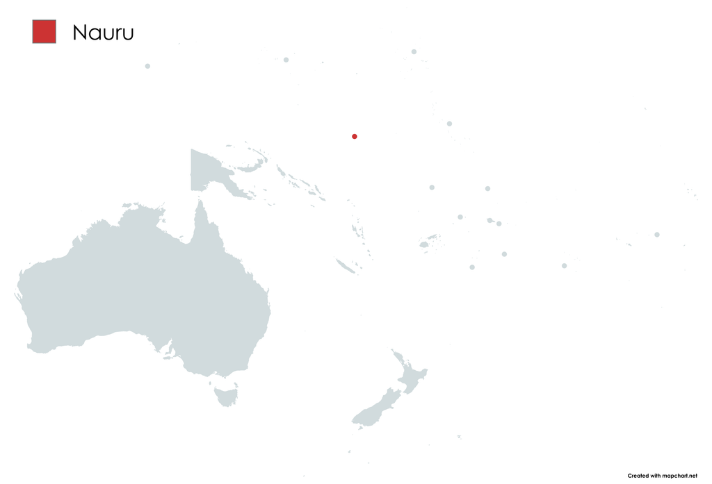
Nauru 🇳🇷 is a small island country and microstate in the South Pacific Ocean, within the Micronesian region of Oceania. It lies about 300 km (190 mi) east of Banaba, an island belonging to Kiribati. Yaren serves as the country’s de facto capital. Covering only 21 km² (8.1 sq mi), Nauru is the third-smallest country in the world by area and the smallest Commonwealth member by both land area and population. Its population is approximately 12,000, making it the third-least populous country in the world, excluding dependent territories.
| Official name | Repubrikin Naoero (or Republic of Noero) |
| Capital | Yaren (de facto), none (de jure) |
| Government | Unitary parliamentary republic with an executive presidency under a non-partisan democracy |
| Area (km² / sq mi) | 21 (8.1) |
| Population | 12,025 (2025) |
| Official language(s) | Nauruan and English |
| Demonym(s) | Nauruan and dei-Naoero |
| Currency | Australian dollar (AUD) |
| Anthem | “Nauru Bwiema” (Nauru, Our Homeland) |
| Flag | 🇳🇷 |
| Flag meaning | The blue represents the Pacific Ocean, the yellow stripe represents the Equator, and the 12-pointed white star represents Nauru and its traditional twelve tribes. |
History of Nauru
Nauru was settled by Micronesian peoples at least 3,000 years ago, with possible Polynesian influence. Its long isolation helped produce a distinctive language and culture. Traditionally, society was divided into twelve matrilineal clans, represented by the twelve-pointed star on the national flag. Islanders also practiced fish farming in Buada Lagoon, while coconuts and pandanus were important foods.
The first European to record Nauru was British captain John Fearn in 1798, who called it “Pleasant Island.” Regular contact with European traders and whalers began in the 19th century, while firearms and alcohol contributed to the Nauruan Civil War (1878–1888). Germany annexed Nauru in 1888, and Christian missionaries arrived soon afterwards.
The discovery of phosphate in 1900 transformed the island’s economy, with commercial mining beginning in 1906. Australia occupied Nauru during World War I, after which it became a League of Nations mandate administered by Australia, Britain, and New Zealand. Mining expanded rapidly, while an influenza epidemic and colonial tensions severely affected the population.
During World War II, Nauru was attacked by German ships and then occupied by Japan in 1942. Around 1,200 Nauruans were deported to Chuuk for forced labour, with survivors returning after the Japanese surrender in 1945. Nauru became a UN Trust Territory in 1947, although Australia retained most administrative power.
Extensive phosphate mining caused severe environmental degradation, leading Australia to propose relocating the population to Curtis Island in the 1960s. Nauruans rejected the plan because they wanted independence and sovereignty. Nauru became self-governing in 1966 and achieved independence on 31 January 1968, with Hammer DeRoburt as its first president. Phosphate revenues initially made Nauru one of the world’s wealthiest countries, but the industry eventually declined and left extensive environmental damage. In 1989, Nauru successfully brought a case against Australia before the International Court of Justice, leading to an agreement on rehabilitation of mined land.
Geography of Nauru
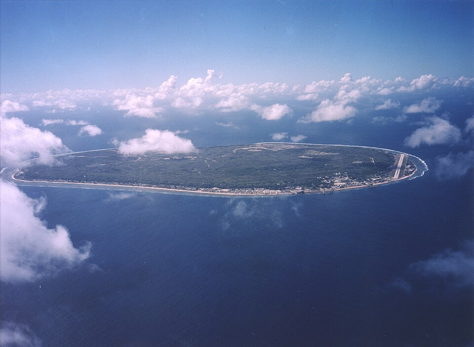
Nauru is a small, 21 km² (8.1 sq mi) oval-shaped island in the southwestern Pacific. It is surrounded by a fringing coral reef, which is exposed at low tide and makes the construction of a conventional seaport difficult, although channels allow small boats to reach the island. A narrow, fertile coastal belt extends around the island, while the interior consists mainly of a raised plateau surrounded by coral cliffs. Command Ridge, the highest point, reaches 71 m (233 ft) above sea level.
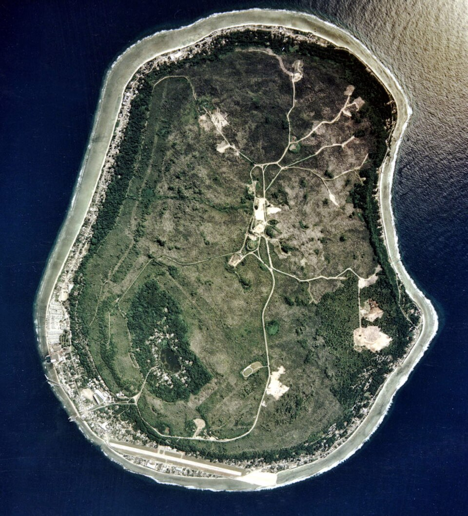
Most of Nauru’s productive land lies along the coast, where coconut palms grow, while the area around Buada Lagoon supports bananas, pineapples, pandanus, and native hardwoods. The island was once one of the Pacific’s major phosphate-producing islands, but its deposits are now almost exhausted. Intensive mining devastated around 80% of the land, leaving much of the central plateau covered by barren limestone formations and severely damaging surrounding marine ecosystems.
Nauru has no rivers, and its wildlife is relatively limited because of habitat destruction and the loss of vegetation. Several native bird species have declined or disappeared, while around 60 native plant species are recorded, none of them endemic. The island has no native land mammals, but supports indigenous birds, insects, and land crabs. Species such as Polynesian rats, cats, dogs, pigs, and chickens were later introduced by humans.
Climate
Nauru has a hot and highly humid tropical climate throughout the year, moderated by its location near the equator and surrounded by ocean. The main monsoon season occurs from November to February, although rainfall varies considerably from year to year and is strongly affected by the El Niño–Southern Oscillation, sometimes causing severe droughts. Daytime temperatures generally remain around 30–35 °C (86–95 °F), while nights stay close to 25 °C (77 °F).
Because Nauru has no rivers or permanent streams, freshwater is collected mainly through rainwater harvesting from roofs or transported to the island by ships returning to collect phosphate.
Society of Nauru
Demography
Nauru had a population of about 12,025 in 2025, although this was lower than in previous decades after around 1,500 foreign workers left the country following major job losses in the phosphate industry.
Languages
The official languages are Nauruan and English. Nauruan is a distinct Micronesian language spoken by most ethnic Nauruans at home, while English is widely used in government and commerce.
Religions
Christianity is the dominant religion. In 2021, the largest denominations were the Nauru Congregational Church (34.3%), Roman Catholicism (33.9%), and the Assemblies of God (11.7%). Although the constitution guarantees freedom of religion, some restrictions have affected smaller groups, including the Church of Jesus Christ of Latter-day Saints and Jehovah’s Witnesses.
Economy of Nauru
Nauru’s economy was at its strongest during the 1970s, when phosphate mining generated most of the country’s income and GDP reached a peak in 1981. As phosphate production declined from the early 1980s, Nauru became increasingly dependent on imports and foreign assistance. Small-scale phosphate extraction continues, with part of the revenue placed in the Nauru Phosphate Royalties Trust, originally established to provide long-term financial support after the reserves were exhausted.
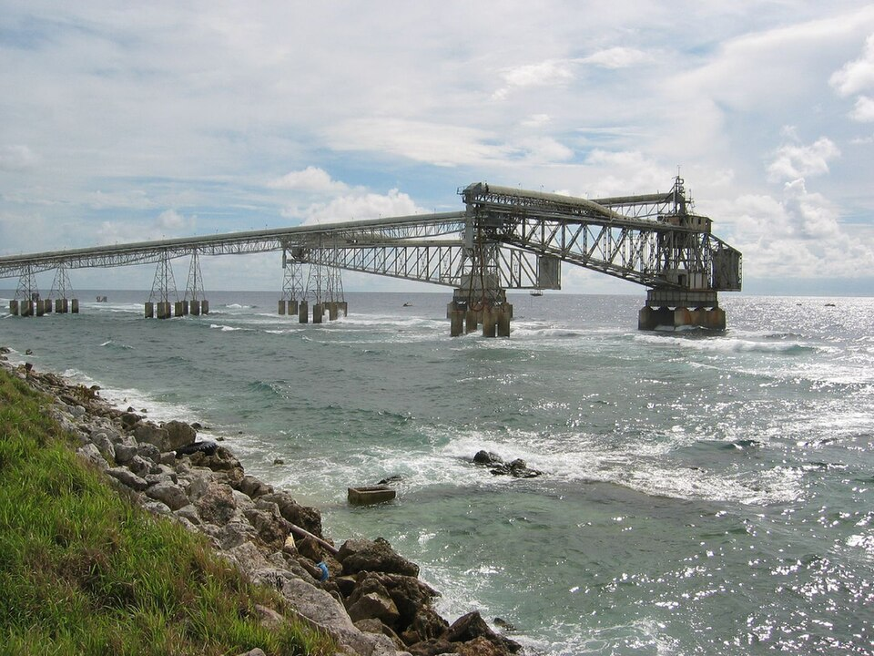
Poor management and unsuccessful investments severely reduced the trust’s wealth, which fell from around A$1.3 billion in 1991 to A$138 million in 2002. The government subsequently struggled to finance basic services, while the National Bank of Nauru became insolvent and closed in 2006. Unemployment has remained high, and the public sector employs most of the country’s workforce. Tourism makes only a limited contribution, leaving Nauru heavily reliant on external assistance and a narrow economic base.
During the 1990s, Nauru also developed into an offshore financial centre and tax haven, allowing foreigners to obtain passports and establish banks with few requirements. International criticism over money laundering led to stronger financial regulations in 2003, after which the country was removed from the FATF’s list of non-cooperative jurisdictions in 2005. From 2001 to 2007, and again after 2012, Australia’s Nauru detention centre became another important source of government revenue, accounting for a substantial share of GDP by 2017.
More recently, Nauru has sought to diversify its economy. It has explored deep-sea mining, particularly the extraction of manganese nodules, while continuing to rely heavily on external funding. In March 2025, the government announced a citizenship-by-investment programme, with the proceeds intended partly to help relocate most of the population to a new settlement on higher ground.
Culture in Nauru
Angam Day, celebrated on 26 October, commemorates the recovery of the Nauruan population following the losses caused by the two World Wars and the 1920 influenza epidemic. Although Western and colonial influences have greatly weakened traditional culture, some elements of Nauruan heritage survive, particularly in music, dance, crafts, fishing, and other traditional practices.
Traditional Nauruan music includes folk songs such as Oh Bwio Eben Bwio, while rhythmic singing and the traditional reigen are often performed during celebrations. Older dances include the fish dance, while the frigate bird dance and dogoropa remain known contemporary forms. Nauru’s national anthem is Nauru Bwiema (“Song of Nauru”).
Nauru has a small media sector. There are no daily newspapers, although Mwinen Ko is published every two weeks. Nauru Television (NTV), a state-owned broadcaster, airs programmes from Australia and New Zealand, while Radio Nauru provides non-commercial programming from Radio Australia and the BBC.
Cuisine of Nauru
This country is notable for having one of the world’s highest obesity rates, reflecting significant changes in its traditional diet. Nauruan food has been strongly influenced by Chinese cuisine, partly because the Chinese community is the island’s largest foreign population and is particularly active in the restaurant sector, especially around Yaren. The local cuisine has also absorbed substantial European influences, most notably from Australian cuisine, which itself developed through the adaptation of European culinary traditions.
Common ingredients
Historically, Nauruan households maintained subsistence gardens that supplied much of their daily food. Common crops included coconuts, breadfruit, bananas, pandanus, papayas, and guavas, while the arrival of immigrant workers from phosphate-mining communities introduced additional crops. The raised phosphate plateau, known locally as the “Topside,” was once highly fertile, whereas the unmined coastal areas have relatively poor, shallow and alkaline soils. By 2011, only about 13% of households still maintained gardens or cultivated crops.
Decades of phosphate mining destroyed around 90% of Nauru’s arable land, removing much of the original soil and forcing the population to import soil for cultivation. The loss of vegetation has also weakened the traditional cultural connection with the land, since plants historically had numerous practical, nutritional and cultural uses.
Today, virtually all food is imported, and the local diet relies heavily on processed foods, particularly staples such as rice and sugar. This dependence on imported food, combined with broader social and historical changes, has had significant consequences for nutrition and public health. Despite the lack of local agricultural production, however, a 2012–2013 household survey found no incidence of food poverty according to the national food-poverty threshold.
Common dishes
A traditional Nauruan dish is coconut fish, usually consisting of tuna, served in coconut milk together with seasonal ingredients. Two traditional foods have specific Nauruan names: epo or épo, referring to the fruits of Pandanus tectorius, and ini, meaning coconut, either served alone or combined with other ingredients.
Culinary traditions and customs
Because most Nauruans are Christians, Christmas is commonly celebrated with Christmas cake prepared using bananas and coconut. On special occasions, other desserts may also be served, including coconut-based mousse.
Administrative and geo-cultural divisions of Nauru
Due to its extremely small territory, Nauru is not divided into distinct geocultural regions, as geographical and cultural differences within the country are too limited to justify such subdivisions.
Administratively, however, Nauru is divided into 14 administrative districts:
- Aiwo
- Anabar
- Anetan
- Anibare
- Baiti
- Boe
- Buada
- Denigomodu
- Ewa
- Ijuw
- Meneng
- Nibok
- Uaboe
- Yaren
Traditional recipes of Nauru
(Only recipes unique to the area or strongly associated with it and rarely found elsewhere are included)
Traditional products of Nauru
(Only products unique to the area or strongly associated with it and rarely found elsewhere are included)
Recipes commonly prepared in Nauru
(Only products specific to this territorial level, and not already covered at a broader administrative or geocultural level, are included)
Products commonly consumed in Nauru
(Only recipes specific to this territorial level, and not already covered at a broader administrative or geocultural level, are included)

Source(s):
https://en.wikipedia.org/wiki/Nauru
https://it.wikipedia.org/wiki/Cucina_nauruana
Photo(s):
1. Map created with https://www.mapchart.net
2. U.S. Department of Energy’s Atmospheric Radiation Measurement Program, Public domain, via Wikimedia Commons
3. ARM, Public domain, via Wikimedia Commons
4. d-online, CC BY-SA 2.0 https://creativecommons.org/licenses/by-sa/2.0, via Wikimedia Commons